Eugene Ruehlmann, former Cincinnati Mayor, will be missed

By:  Suzanne Maggard

Construction of Riverfront Stadium

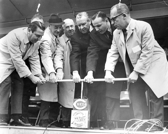
Construction of Riverfront Stadium begins, Eugene Ruehlmann is second from the right

We began our Monday in the Archives and Rare Books Library with the sad news that a dear friend of our library passed away over the weekend.  Former Cincinnati mayor and city councilman, Eugene Ruehlmann died on Saturday June 8 at the age of 88.  Since the Archives and Rare Books Library holds his papers, I had the pleasure of assisting Mr. Ruehlmann on several occasions.  For someone so accomplished, I always found Mr. Ruehlmann incredibly approachable, easy to talk to, and humble.  Our student workers especially enjoyed meeting and talking with him.  He will be greatly missed.

Ruehlmann, 1947

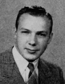
Eugene Ruehlmann, 1947, from The Cincinnatian Yearbook

Eugene Ruehlmann, the second youngest of John and Hattie Ruehlmann’s ten children, was born in 1925.  He grew up on Cincinnati’s West Side and attended Western Hills High School and graduated in 1943.  After high school, he joined the U.S. Marines and served in World War II.  He then entered the University of Cincinnati, where he was a successful and active student.  Ruehlmann was a member of Beta Theta Phi, ODK, and Sophos and was on the board of The Cincinnatian (yearbook) and was a member of the varsity football team.  He graduated with honors in 1948 with a degree in Political Science and received the McKibbin Medal from the College of Arts and Sciences.  Ruehlmann earned his law degree in 1950 from Harvard. Continue reading

False Facades Offer Aesthetic Disguise = Adventures in the Subway and Street Improvements Digitization Project

By Angela Vanderbilt

The story of abandoned subway stations and tracks hidden beneath busy city streets is not unique to Cincinnati. Other large cities, such as New York, London, and Paris have similarly mysterious and intriguing stories to tell. An article I recently read in The New York Times introduced me to this underground world of hidden subway ventilation shafts disguised by false building facades, with doors from which people occasionally exit, but never seem to enter. Some of these subterranean secrets are in use, while others have been abandoned like Cincinnati’s own subway stations beneath Central Parkway.

What’s fascinating is the effort made to disguise these facilities, to blend them in with the neighboring buildings. While it seems a logically aesthetic means of making the utilitarian more appealing, some have argued that the cities in which these structures are located are trying to hide a deep secret. For comparison, consider the Cincinnati subway – when the subway and Central Parkway were first being constructed, the ventilation chimneys and the entrances to the below-ground stations were nicely appointed with decorative stonework.

Ventilation Shart

Ventilation shaft, looking north along Parkway from Liberty St., July 2, 1928

Ventilation Shaft

Close up of decorative stonework for ventilator railing, Central Parkway,
Nov. 19, 1928

Continue reading

What Style is That? = Adventures in the Subway and Street Improvements Digitization Project

By Angela Vanderbilt

Row House

3926 Feemster Street, June 17, 1932

The photographs contained in the Subway and Street Improvements collection are a valuable source of information for anyone who might be researching the urban development and built environment of Cincinnati in the period surrounding the turn of the 20th century. Many of the images in the collection capture buildings and homes in Cincinnati’s downtown district and the surrounding neighborhoods as the city grew and expanded up the hills and along the Ohio River. And because the photographer wrote location and date information on the negatives, anyone interested in finding a picture of the house in which their grandparents or great-grandparents lived in 1923 may very well find it within this collection. Continue reading

Slip, Slide and A Parkway = Adventures in the Subway and Street Improvements Digitization Project

By:  Angela Vanderbilt

Cincinnatians who drive along Columbia Parkway from downtown to the eastern suburbs know the parkway for its breathtaking scenic views of the Ohio River below. But these commuters also know the danger of driving along this parkway after a quick, heavy downpour or a prolonged period of rain-drenched days.

Landslide along railroad tracks

Columbia Parkway Bridge

The hillside embankment along the parkway, cut at a steep angle when the road was constructed in 1938, is well known for becoming unstable after heavy rainfalls, causing mudslides that leave debris strew across the roadway as it passes over the low retaining wall at its base. One of three major urban projects undertaken by the city during the 1930s, nearly half the cost of the parkway was paid for by a grant from the Works Project Administration. In 1929, the city of Cincinnati passed an ordinance to upgrade and expand the existing road, which at that time was named Columbia Avenue and was a simple dirt and gravel road that meandered above the Ohio River eastward from downtown. Continue reading

Going to Market = Adventures in the Subway and Street Improvements Digitization Project

By:  Angela Vanderbilt

One of the country’s oldest surviving public market houses to operate on a continual basis, Findlay Market is one of the nine original municipal markets that were open for business in downtown Cincinnati at the turn of the 20th century. The major source of goods for Cincinnati’s densely populated urban center, these markets began operating in the early 1800’s and continued to provide fresh produce and other goods to local residents through the mid-1960s, with Findlay Market being the sole survivor in the downtown area.

Shoppers returning from Findlay Market

Shoppers returning from Findlay Market, June 25, 1920

Findlay Market

Findlay Market, 2007

Continue reading

Abandoned but not Forgotten = Adventures in the Subway and Street Improvements Digitization Project

By:  Angela Vanderbilt

The fascination and level of interest in Cincinnati’s attempt to build a subway is as alive today as it was when the first shovel-full of dirt was lifted from the canal bed in January, 1920. For some, it is a fascination with Cincinnati’s history, a desire to learn more about how their city has developed. For others, it is a fascination with what lies beneath Central Parkway, the desire to walk the tunnels through which no subway train has ever run.

Inspecting the Subway construction

Inspecting the construction, March 17, 1920

Continue reading

Brighton Bridge = Adventures in the Subway and Street Improvements Digitization Project

By:  Angela Vanderbilt

Brighton Bridge, which spans Central Parkway connecting Colerain Avenue with McMicken Avenue, was built during the construction of Section Four of the subway. The last portion of subway to be constructed in the former Miami-Erie Canal bed, Section Four extended from Mohawk Street to Brighton’s Corner, and included an underground station at Brighton.

Canal Footbridge

Continue reading

Getting Around = Adventures in the Subway and Street Improvements Digitization Project

By Angela Vanderbilt

In keeping with the neighborhood theme of last week’s blog, I wanted to take a closer look at some of the neighborhoods through which the collection of subway and street improvement photographs passes. The collection is a fantastic study of Cincinnati’s urban development as the city grew in those early decades of the 20th century and some neighborhoods expanded and others were established. Many of the streets and boulevards that bounded the neighborhoods of the collection have changed over time, with expansion as well as other city infrastructure improvements.

The collection begins its journey in downtown Cincinnati along “Canal Street”, known today as Central Parkway. The earliest photographs in the collection focus on subway construction work between Walnut Street to the east and Plum Street to the west, as well as street improvement work around the downtown area and along the riverfront. Using the information written on the negatives, we are able to identify the specific location of the majority of photographs on a map. However, some of the streets and alleys named in the photographs in this section of downtown no longer exist. High-rise office buildings, convention centers, and sports arenas now occupy the spaces through which they once ran. Continue reading

Plotting Coordinates = Adventures in the Subway and Street Improvements Digitization Project

By:  Angela Vanderbilt

The proposed subway route crossed through several neighborhoods north and west of downtown Cincinnati, as did the street improvement projects of the 1920s – 1950s. Whether the project involved razing a bridge over the canal to make room for bulldozers or digging trenches to lay new sewer lines before paving streets, the photographers captured these streets and neighborhoods in their images, and noted the location in the majority of photographs.

As mentioned in the blog “A Changing Landscape”, negatives of the subway project have date and location information written along the outer edge. When printed, this information is not visible. But later photographs, and the majority of street improvement photographs, have this information directly within the frame of the image, which was made visible when printed. Generally located in the lower left corner, this information provides the viewer with a quick and easy point of reference. Continue reading

Behind the Lens = Adventures in the Subway and Street Improvements Digitization Project

By:  Angela Vanderbilt

As I’ve mentioned in earlier blog postings, the identity of the subway and street improvements photographer – or more likely, photographers, due to the 30-year time span of the collection – was not known at the outset of our digitization project. As more negatives are sent for scanning, we’ve gotten closer to revealing the identity.

Just last week, our scanning service came across a negative with “Photo by L.G. Folger” written at the bottom, below the date and location of the photograph. Very exciting news! This same name has also been found on the back of printed photographs. This is definitely a step in the right direction, considering it was found written directly on a negative as well as on prints! Other prints have a round stamp on the back with the information “W.T. Myers & Co., 238 E. 4th St., Cincinnati, Ohio”.

L.G. Folger Signature

Continue reading