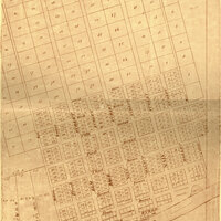
Plan of the town of Cincinnati for 1802
Item
- Title
- Plan of the town of Cincinnati for 1802
- Creator
- Israel Ludlow
- Date
- 1802
- Description
-
This is an enlarged facsimile of Robert Clarke's reproduction of original records maintained by Cincinnati settler Israel Ludlow. Included is Ludlow's plan of the town of Cincinnati for 1802. The plan is accompanied by a list of the settlers to whom each lot was sold in 1789. The land that would become Cincinnati was purchased in 1788 by Matthias Denman from John Cleves Symmes and was named "Losantiville." General Arthur St. Clair renamed the town "Cincinnati" in 1790.
This image is taken from the following book:
Record of the distribution and sale of lots in the town of Losantiville (now Cincinnati) 1789 by Robert Clarke
Rare Books Call Number: F499.C5 R411957
- Item sets
- Cincinnati Historical Maps
- Site pages
- Historical Maps of the City of Cincinnati
- Media
 Plan of Cincinnati 1802
Position: 2 (762 views)
