
Last November, the University of Cincinnati Libraries announced the award of an Archives Grant from the National Historical Publications and Records Commission to the Libraries’ Archives and Rare Books Library (ARB). This grant supports the archival processing of records related to the lawsuit Bronson v. Board of Education of the City School District of the City of Cincinnati maintained by the local branch of the National Association for the Advancement of Colored People (NAACP) and donated to the University of Cincinnati in the 1980s.
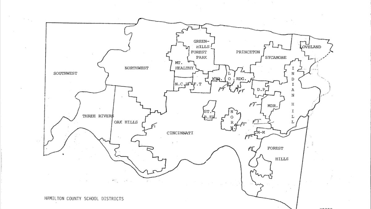
The suburban school districts
On November 15, 1976, two years after Bronson v. Board was filed, 19 suburban school districts were added to the lawsuit due to districts’ racial discrimination actions and to implement a county-wide desegregation plan following the suit. The school districts included: Deer Park, Finneytown, Forest Hills, Greenhills-Forest Park, Indian Hill, Lockland, Madeira, Mariemont, Mt. Healthy, North College Hill, Northwest, Norwood, Oak Hills, Princeton, Reading, St. Bernard-Elmwood Place, Sycamore, Three Rivers and Wyoming school districts.
Below are histories of the various school districts found within the Bronson v. Board records. The information reflects statistics and information as of 1979.
School district histories
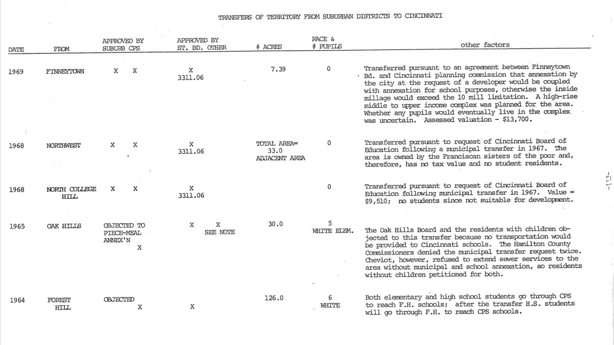
- Deer Park: The district formed in 1826 and originally included Amberly and Silverton which were annexed to Cincinnati Public Schools in the 1930s and 1940s. Concord Park from the Indian Hill School District was annexed in 1945-1946. The racial composition of the district in 1979 was 3.7% Black.
- Finneytown: The district is under the jurisdiction of Hamilton County Board of Education. It did not have any senior high schools until the 1960s. Land was annexed from the Greenhills-Forest Park school district in 1960. Finneytown gave Cincinnati Public Schools land in 1951 and 1969. As of 1979, 7.1% of the student population was Black.
- Forest Hills: Created when Newton and Anderson school districts merged in 1957, Forest Hills gained a large transfer of land in 1970 that affected 44 students, which was found to be racially motivated and was quickly reversed. Only 0.4% of the student population was Black in 1979.
- Greenhills-Forest Park: This district was established as a result of two school districts, Greenhills and Forest Park, combining in 1963 shortly after Forest Park was incorporated as a city. The majority of the 23.8% Black students of the district lived in Forest Park by 1979.
- Indian Hill: The Indian Hill district was formed in 1936 with the consolidation of Jefferson, Franklin, Washington, Remington, and Camp Dennison school districts. Indian Hill has annexed land from Madeira, Mariemont, Terrace Park, Deer Park, Milford and Sycamore school districts. Housing discrimination has been recognized in this district and as a result in 1979 only 2.2% of the student population was Black.
- Lockland: The Lockland school district includes the Village of Arlington Heights. In 1960 Lockland received a small area of land in Springfield Township from Cincinnati Public Schools which included 76 white students. The district experienced a lawsuit in 1974 concerning tuition students and racial balancing. There were a few all-Black schools that closed in the 1950s and 1960s. As of 1979 the student population was 17.3% Black.
- Madeira: The district was created by annexed land from Cincinnati Public Schools and the Indian Hill school district. Restrictive covenants were noted as reasoning for low population of non-white students. As of 1979, the school district had one Black student which equaled 0.1% of the student population.
- Mariemont: This district originally consisted of the Plainville and Fairfax school districts which consolidated in 1942. Later on, Mariemont received the Terrace Park school district and lost Fairfax. Over time, Mariemont annexed land from Cincinnati Public Schools, Indian Hill and Milford school districts. Restrictive covenants had occurred which caused the student population’s racial composition to be 0.3% Black.
- Mt. Healthy: The only school district to be dismissed from the 1976 amended trial complaint that brought in the suburban school districts to the Cincinnati Board of Education lawsuit. In 1978, Mt. Healthy School District filed a court memorandum arguing that the district had already integrated through redistricting. It was found that the district had continued to keep integration intact even with the Black student population at 28% in 1978 which was equal throughout all their schools.
- North College Hill: This district includes the city of North College Hill and some parts of Springfield Township. There was an all-Black school for the Steele subdivision that closed in 1964. Mt. Healthy annexed territory that included mostly Black students from the North College Hill school district before the closure of the segregated school. As of 1979, the population of students was 16.8% Black.
- Northwest: The Northwest district formed when Monfort Heights and Colerain school districts merged in 1960. Northwest had been annexed land from Mt. Healthy school district, but this was a small area with just one student residing in the area. One school was created when the school district was experiencing an increase in the Black population, but the school was built near a large white middle-class neighborhood. The student population as of 1979 was 6.5% Black.
- Norwood: Norwood has existed as one entity since the late 1800s. As of 1979, the Black population did not accurately represent the 0.1% Black student population as many families at this time did not have school-aged children. The school district had no Black staff as of 1979 as the district had a residency requirement for employment. Various instances of housing discrimination have been carried out within the city of Norwood.
- Oak Hills: The Oak Hills district formed with the consolidation of Bridgetown, Delhi and Green school districts in 1956. The school district did not have a high school until 1959 when one was built after Cincinnati Public Schools stopped allowing tuition students from Oak Hills. Portions of Cheviot were annexed to Cincinnati Public Schools in 1963 and 1965. The district was 0.1% Black in 1979.
- Princeton: This district was created when Woodlawn, Crescentville, Glendale, Runyan, Evendale, Stewart, Sharonville and Springdale school districts joined together in 1955. Princeton was annexed land from Greenhills-Forest Park, Wyoming, and Lockland school districts. In 1970, the Ohio State Department of Education merged Princeton with Lincoln Heights School District in order to integrate the all-Black Lincoln Heights with the all-white Princeton School District. In the six years in between the merger and Princeton’s addition to the Bronson trial, the school district continued its segregated patterns bringing the percentage of Black students in Princeton to 32.9% by 1979.
- Reading: Land for the Reading school district had been annexed from Cincinnati Public Schools and Deer Park. The Canterbury Gardens housing project increased the student population to 8.2% Black as of 1979.
- St. Bernard-Elmwood Place: The two school districts became one in 1968 due to a state recommendation when both districts faced decreasing enrollment. Instead of both districts joining Cincinnati Public Schools, they merged. As of 1979 the student enrollment was 1.6% Black.
- Sycamore: The district was originally made up of the Blue Ash, Plainfield, Montgomery, White Oak, Weller and Sixteen Mile Stand school districts. They joined together when the white area of White Oak district attempted to transfer to Blue Ash schools, which would segregate the schools. Hamilton County Board of Education did not allow it to occur and instead consolidated the six districts. The district has annexed several areas to Loveland and Indian Hills over time. By 1979 the student population was 4.1% Black.
- Three Rivers: This district was created in 1956 when Addyston, Cleves-North Bend and Miami school districts merged. The student population was 2.5% Black by 1979.
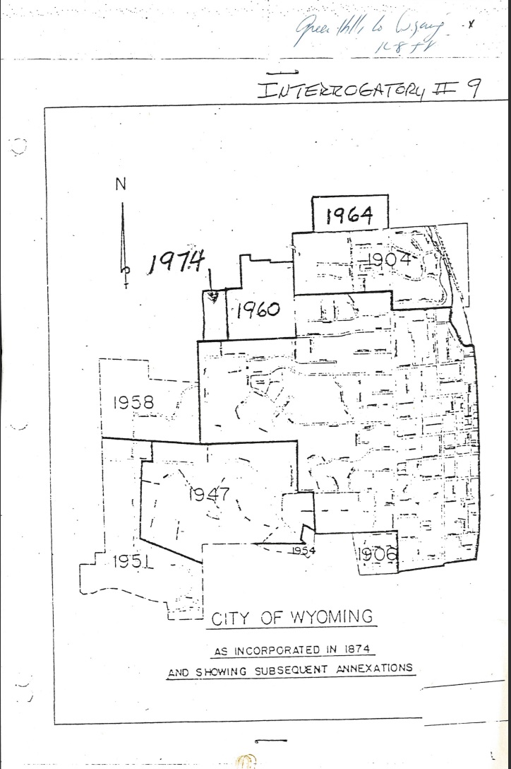
- Wyoming: The majority of the Black population in this district lived in the Greenwood subdivision since the mid-1800s. The segregated schools closed by the mid-1950s. Wyoming had been annexed land from Cincinnati Public Schools, Finneytown and Greenhills-Forest Park school districts. As of 1979, 10.3% of the student population was Black.
This project has been made possible in part by grant RH-104772-24 from the National Historical Publications and Records Commission (NHPRC). Any views, findings, conclusions, or recommendations expressed in this blog post do not necessarily represent those of the NHPRC.