Paving the Way through Cincinnati = Adventures in the Subway and Street Improvements Digitization Project

By:  Angela Vanderbilt

Downtown Cincinnati at the turn of the 20th century was a bustling business and commercial center, but with a dangerous mixture of pedestrians, horse-pulled wagons and carriages, street cars, and unseasoned automobile drivers. Add to this a mess of unpaved or cobblestoned streets, a lack of traffic laws, speed limits, and stop signs at intersections, with streetcar tracks criss-crossing lanes. It was a recipe for disaster.

Miami & Erie Canal

On the left, deliveries to the Raschig School are unloaded from a horse-drawn wagon while, on the right, automobiles park along a drained Miami & Erie Canal, looking east down Canal Street as subway construction begins, April 20, 1920

Continue reading

False Facades Offer Aesthetic Disguise = Adventures in the Subway and Street Improvements Digitization Project

By Angela Vanderbilt

The story of abandoned subway stations and tracks hidden beneath busy city streets is not unique to Cincinnati. Other large cities, such as New York, London, and Paris have similarly mysterious and intriguing stories to tell. An article I recently read in The New York Times introduced me to this underground world of hidden subway ventilation shafts disguised by false building facades, with doors from which people occasionally exit, but never seem to enter. Some of these subterranean secrets are in use, while others have been abandoned like Cincinnati’s own subway stations beneath Central Parkway.

What’s fascinating is the effort made to disguise these facilities, to blend them in with the neighboring buildings. While it seems a logically aesthetic means of making the utilitarian more appealing, some have argued that the cities in which these structures are located are trying to hide a deep secret. For comparison, consider the Cincinnati subway – when the subway and Central Parkway were first being constructed, the ventilation chimneys and the entrances to the below-ground stations were nicely appointed with decorative stonework.

Ventilation Shart

Ventilation shaft, looking north along Parkway from Liberty St., July 2, 1928

Ventilation Shaft

Close up of decorative stonework for ventilator railing, Central Parkway,
Nov. 19, 1928

Continue reading

Digitized Correspondence and Photographs of Albert B. Sabin Available on the Web

sabin1
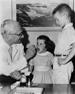
The University of Cincinnati Libraries have completed a  three-year project to digitize the correspondence and photographs of Albert B. Sabin,  developer of the oral polio vaccine and distinguished service professor at the University of Cincinnati’s College of Medicine and Children’s Hospital Research Foundation from 1939-1969.

The collection is freely and publicly available via the Albert  B. Sabin website at http://sabin.uc.edu/ and includes approximately 35,000 letters and accompanying documents totaling 50,000 pages of correspondence between Sabin and political, cultural, social, and scientific leaders around the world. Also included are nearly 1,000 photographs documenting the events and activities worldwide that were part of Sabin’s crusade to eradicate polio. Continue reading

Slip, Slide and A Parkway = Adventures in the Subway and Street Improvements Digitization Project

By:  Angela Vanderbilt

Cincinnatians who drive along Columbia Parkway from downtown to the eastern suburbs know the parkway for its breathtaking scenic views of the Ohio River below. But these commuters also know the danger of driving along this parkway after a quick, heavy downpour or a prolonged period of rain-drenched days.

Landslide along railroad tracks

Columbia Parkway Bridge

The hillside embankment along the parkway, cut at a steep angle when the road was constructed in 1938, is well known for becoming unstable after heavy rainfalls, causing mudslides that leave debris strew across the roadway as it passes over the low retaining wall at its base. One of three major urban projects undertaken by the city during the 1930s, nearly half the cost of the parkway was paid for by a grant from the Works Project Administration. In 1929, the city of Cincinnati passed an ordinance to upgrade and expand the existing road, which at that time was named Columbia Avenue and was a simple dirt and gravel road that meandered above the Ohio River eastward from downtown. Continue reading

Going to Market = Adventures in the Subway and Street Improvements Digitization Project

By:  Angela Vanderbilt

One of the country’s oldest surviving public market houses to operate on a continual basis, Findlay Market is one of the nine original municipal markets that were open for business in downtown Cincinnati at the turn of the 20th century. The major source of goods for Cincinnati’s densely populated urban center, these markets began operating in the early 1800’s and continued to provide fresh produce and other goods to local residents through the mid-1960s, with Findlay Market being the sole survivor in the downtown area.

Shoppers returning from Findlay Market

Shoppers returning from Findlay Market, June 25, 1920

Findlay Market

Findlay Market, 2007

Continue reading

Abandoned but not Forgotten = Adventures in the Subway and Street Improvements Digitization Project

By:  Angela Vanderbilt

The fascination and level of interest in Cincinnati’s attempt to build a subway is as alive today as it was when the first shovel-full of dirt was lifted from the canal bed in January, 1920. For some, it is a fascination with Cincinnati’s history, a desire to learn more about how their city has developed. For others, it is a fascination with what lies beneath Central Parkway, the desire to walk the tunnels through which no subway train has ever run.

Inspecting the Subway construction

Inspecting the construction, March 17, 1920

Continue reading

Brighton Bridge = Adventures in the Subway and Street Improvements Digitization Project

By:  Angela Vanderbilt

Brighton Bridge, which spans Central Parkway connecting Colerain Avenue with McMicken Avenue, was built during the construction of Section Four of the subway. The last portion of subway to be constructed in the former Miami-Erie Canal bed, Section Four extended from Mohawk Street to Brighton’s Corner, and included an underground station at Brighton.

Canal Footbridge

Continue reading

Getting Around = Adventures in the Subway and Street Improvements Digitization Project

By Angela Vanderbilt

In keeping with the neighborhood theme of last week’s blog, I wanted to take a closer look at some of the neighborhoods through which the collection of subway and street improvement photographs passes. The collection is a fantastic study of Cincinnati’s urban development as the city grew in those early decades of the 20th century and some neighborhoods expanded and others were established. Many of the streets and boulevards that bounded the neighborhoods of the collection have changed over time, with expansion as well as other city infrastructure improvements.

The collection begins its journey in downtown Cincinnati along “Canal Street”, known today as Central Parkway. The earliest photographs in the collection focus on subway construction work between Walnut Street to the east and Plum Street to the west, as well as street improvement work around the downtown area and along the riverfront. Using the information written on the negatives, we are able to identify the specific location of the majority of photographs on a map. However, some of the streets and alleys named in the photographs in this section of downtown no longer exist. High-rise office buildings, convention centers, and sports arenas now occupy the spaces through which they once ran. Continue reading

Plotting Coordinates = Adventures in the Subway and Street Improvements Digitization Project

By:  Angela Vanderbilt

The proposed subway route crossed through several neighborhoods north and west of downtown Cincinnati, as did the street improvement projects of the 1920s – 1950s. Whether the project involved razing a bridge over the canal to make room for bulldozers or digging trenches to lay new sewer lines before paving streets, the photographers captured these streets and neighborhoods in their images, and noted the location in the majority of photographs.

As mentioned in the blog “A Changing Landscape”, negatives of the subway project have date and location information written along the outer edge. When printed, this information is not visible. But later photographs, and the majority of street improvement photographs, have this information directly within the frame of the image, which was made visible when printed. Generally located in the lower left corner, this information provides the viewer with a quick and easy point of reference. Continue reading

Behind the Lens = Adventures in the Subway and Street Improvements Digitization Project

By:  Angela Vanderbilt

As I’ve mentioned in earlier blog postings, the identity of the subway and street improvements photographer – or more likely, photographers, due to the 30-year time span of the collection – was not known at the outset of our digitization project. As more negatives are sent for scanning, we’ve gotten closer to revealing the identity.

Just last week, our scanning service came across a negative with “Photo by L.G. Folger” written at the bottom, below the date and location of the photograph. Very exciting news! This same name has also been found on the back of printed photographs. This is definitely a step in the right direction, considering it was found written directly on a negative as well as on prints! Other prints have a round stamp on the back with the information “W.T. Myers & Co., 238 E. 4th St., Cincinnati, Ohio”.

L.G. Folger Signature

Continue reading